Editie 2026.
NV.Atlas Ostfriesland - Borkum bis Helgoland & Ems

Veilig & snel betalen!

Snelle levering met PostNL!
Combination pack paper & digital download incl. App.
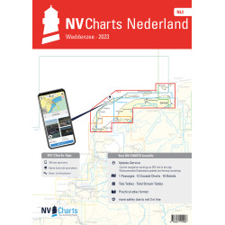
3 Passage Charts, 15 Coastal charts & 16 Details/Plans. Format 30x42cm, bound to Atlas. This chart folio contains a download code for all charts in this area / coverage in the digital nv charts format to be used on a smartphone/tablet with the nv chart app. This app is compatible with Apple: iOS/MacOSX, Android, Windows 7/8/10.
• 3 Passage Charts
• 15 Coastal Charts
• 16 Details
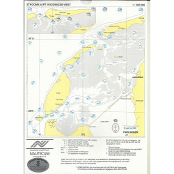
• Tidal Calendar and Currents included
• Digital charts & navigation software and nv charts App
• Harbour plans in paper & digital
• Notices for Navigation in German and English language
nv charts for the North Sea - The Charts for the sea area "Ostfriesland - Island of Borkum to Island of Helgoland & River Ems" are for use by the leisure mariners optimized and professional cartography for the North Sea. All information necessary for the navigation in the challenging waters of the German Bight is provided together with additional harbour plans and details for approaches and passages in these waters. The chart folio also contains tidal data and currents. They are referenced to tidal diamants in the charts.
The atlas format allows a clear structure for navigation. Approaches, ports and anchorage are found fast and easily. All nautical information and important details are available in the charts and in the digital version of the app as well. Tidal data is shown in the software and app. The nv charts cartography is famous for its clever design of the coverages for each chart making best possible use of each scale.
Update
The chart folios for the German North Sea from nv charts are published each year in a fresh and revised edition. For the digital nautical charts a download is provided each spring. Note: up-to-date charts are good seamanship and the base for a safe navigation. NV charts is offering a monthly correction service for charts of the German North Sea from April to October. That way all mariners are always up-to-date.
Passage Charts
C1 Ostfriesland 1 : 375.000
C2 Rottumerplaat bis Norderney 1 : 150.000
C3 Norderney bis Wangerooge 1 : 150.000
Coastal Charts
C4 Westerems 1 : 50.000
C5 Osterems 1 : 50.000
C6 Dovetief 1 : 50.000
C7 Norderney bis Langeoog 1 : 50.000
C8 Spiekeroog 1 : 50.000
C9 Ansteuerung von Helgoland 1 : 50.000
C13 Borkum bis Dukegat 1 : 50.000
C14 Dukegat bis Emder Fahrwasser 1 : 50.000
C15 Ansteuerung Delfzijl 1 : 25.000
C16 Emder Fahrwasser 1 : 25.000
C17A Dollard 1 : 50.000
C18 Unterems bis Leer 1 : 25.000
C19A/B Leer bis Papenburg 1 : 25.000
C20 Papenburg bis Lathen 1 : 50.000
Details
C10 Helgoland 1 : 12.500
C11A Borkum Hafen 1 : 15.000
C11B Dornumersiel 1 : 12.500
C11C Harlesiel 1 : 12.500
C11D Norddeich 1 : 20.000
C11E Bensersiel 1 : 12.500
C11F Langeoog Hafen 1 : 12.500
C11G Neuharlingersiel 1 : 7.500
C11H Norderney Hafen 1 : 12.500
C11J Dove Harle 1 : 25.000
C12A Baltrum Hafen 1 : 7.500
C12B Spiekeroog Hafen 1 : 10.000
C12C Juist Hafen 1 : 7.500
C12D Leysiel Schleuse 1 : 7.500
C12E Greetsiel Hafen 1 : 10.000
C17 Emden 1 : 12.500
General Notes C11
Legend 21
Tide Tables 22-24
Datasheet
Editie 2026.
NV.Atlas Ostfriesland - Borkum bis Helgoland & Ems